Zoning Bylaw
THE RESORT VILLAGE OF B-SAY-TAH
Resort Village of B-Say-Tah

BYLAW NO. _______
A Bylaw of the Resort Village of B-Say-Tah to adopt a Zoning Bylaw.
The Council of the Resort Village of B-Say-Tah, in the Province of Saskatchewan, in open meeting assembled enacts
as follows:
1. Pursuant to Section 34(1) of The Planning and Development Act, 2007 the Council of the Resort Village of B-
Say-Tah hereby adopts the Resort Village of B-Say-Tah Zoning Bylaw, identified as Schedule "A" to this Bylaw.
2. The Mayor and Resort Village Administrator are hereby authorized to sign and seal Schedule "A" which is
attached to and forms part of this Bylaw.
3. Bylaw No. , the Zoning Bylaw, and all amendments thereto, are hereby repealed.
4. This Bylaw shall come into force on the date of final approval by the Minister of Government Relations.
Read a first time this day of
Read a second time this day of
Read a third time this day of
Adoption of bylaw this day of
S E A L
___________________________
Mayor
___________________________
Resort Village Administrator
Certified a true copy of the Bylaw adopted by Resolution of Council on the _______________ day of
_________________ in the year ___________.
A Commissioner for Oaths in the Province of Saskatchewan
My appointment expires_________________.
THE RESORT VILLAGE OF B-SAY-TAH
2

ZONING BYLAW
BYLAW SCHEDULE “A” TO BYLAW NO. ________
OF THE RESORT VILLAGE OF B-SAY-TAH
SEAL
_______________________
Mayor
_______________________
Resort Village Administrator
TABLE OF CONTENTS
Section 1 Introduction Page 5
1.1 Title Page 5
3

1.2 Purpose Page 5
1.3 Scope Page 5
1.4 Severability Page 5
Section 2 Definitions Page 6
Section 3 Administration Page 12
3.1 Development Officer Page 12
3.2 Development Permit Page 12
3.3 Development Permit Procedure Page 13
3.4 Development Not Requiring a Permit Page 14
3.5 Minor Variance Page 14
3.6 Referrals Page 15
3.7 Development Appeals Board Page 15
3.8 Bylaw Amendments Page 16
3.9 Fees Page 16
3.10 Non-conforming Uses, Buildings and Sites Page 16
3.11 Enforcement, Offences and Penalties Page 17
Section 4 General Regulations Page 18
4.1 Licenses, Permits and Compliance with other Bylaws Page 18
4.2 Permitted Encroachments Page 18
4.3 Number of Principal Buildings Permitted on a Lot Page 18
4.4 Signs Page 19
4.5 Public Utilities, Pipelines and Facilities of the Municipality Page 19
4.6 Grading and Levelling of Sites Page 19
4.7 Engineering Analysis Requirements Page 20
4.8 Restoration to a Safe Condition Page 20
4.9 Hazard Lands Page 20
4.10 Home Based Businesses Page 21
4.11 Outdoor Storage Page 22
4.12 Access and Parking Requirements Page 22
4.13 Shoreline Protection Measures Page 22
4.14 Recreational Facilities Requirements Page 22
4.15 Bed and Breakfast Homes Page 23
4.16 Dwelling Groups Page 23
4.17 Accessory Buildings and Structures Page 24
4.18 Recreational Vehicles and Vacation Trailers Page 25
4.19 General Standards and Criteria for Discretionary Uses Page 25
Section 5 Zoning Districts Page 27
5.1 Classification of Zoning Districts Page 27
5.2 Zoning District Map Page 27
5.3 Boundaries of Zoning District Page 27
Section 6 District Schedules Page 28
6.1 Residential District ( R) Page 28
6.2 Recreation District (REC) Page 30
6.3 Business Commercial District (C) Page 32
6.4 Urban Reserve District (UR) Page 34
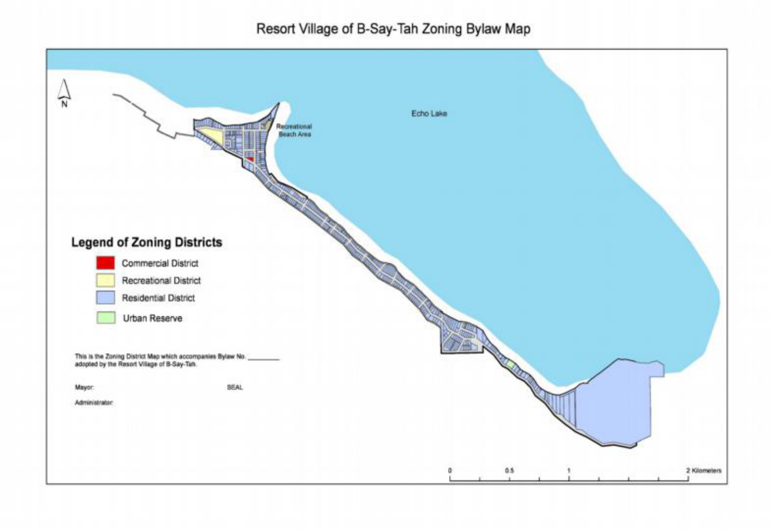
Section 7 Maps Page 36
7.1 Zoning District Map
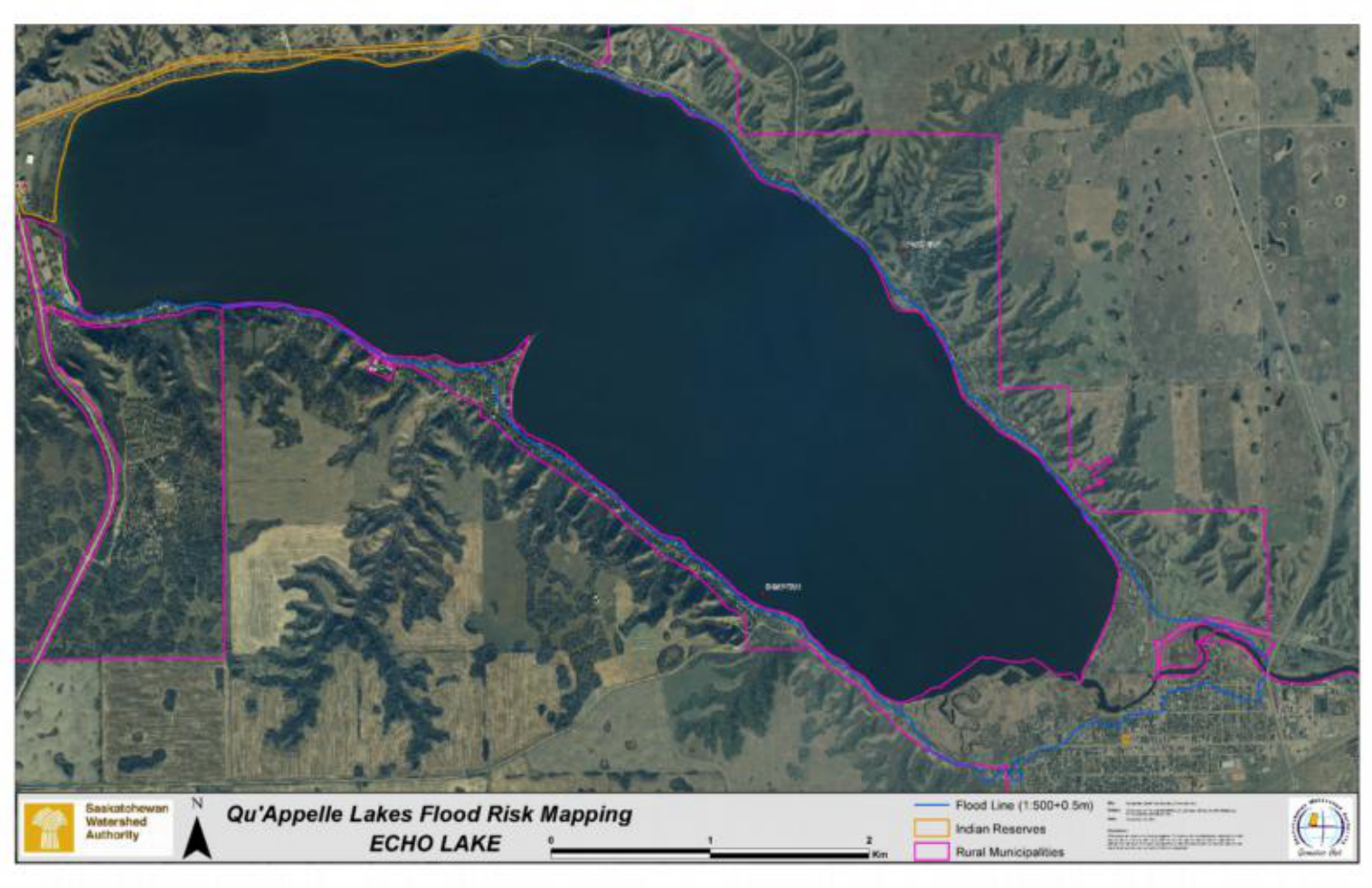
7.2 Flood Hazard Map
SECTION 1 – INTRODUCTION
4

Under the authority of the Planning and Development Act, 2007, as amended, and the Calling Lakes
District Plan, the Council of the Resort Village of B-Say-Tah in the Province of Saskatchewan, in open
meeting, hereby enact as follows:
1.1 Title
This Bylaw shall be known and may be cited as the Zoning Bylaw of the Resort Village of B-Say-
Tah.
1.2 Purpose
The purpose of this Bylaw is to control the use of land in the Resort Village of B-Say-Tah so as to
provide the amenity of the area and for the health, safety and general welfare of the inhabitants
of the Municipality.
1.3 Scope
Development shall be permitted within the limits of the Resort Village of B-Say-Tah only when in
conformity with the provisions of this Bylaw subject to the right of appeal provisions of the Act.
1.4 Severability
If any section, clause or provision of this Bylaw, including anything shown on the Zoning District
Map, is for any reason declared by a Court of competent jurisdiction to be invalid, such decision
shall not affect the validity of the Bylaw as a whole or in part, other than the section, clause,
provision or anything shown on the Zoning District Map, declared to be invalid.
5

SECTION 2 – DEFINITIONS
Wherever in this Bylaw the following words or terms are used, they shall, unless the context otherwise provides, be
held to have the following meaning:
Accessory Use– a use incidental, subordinate,
exclusively devoted to, and located on the same site
as the principal use or building.
Accessory Building – a building incidental,
subordinate, exclusively devoted to, and located on
the same site as the principal use or building. Typical
uses include a private garage, boathouse, storage
shed and other similar structures.
Act - The Planning and Development Act, 2007.
Administrator –the Administrator for the Resort
Village of B-Say-Tah.
Alteration – the structural change in, or addition to,
a building or structure and includes a change from
one type of use to another.
Ancillary Use - a use that is secondary and
subordinate in size, extent and purpose to the
principal use on the same site, but is not necessary
for the operation of the principal use on that site.
Bare Land Condominium - Shall mean a
condominium divided into bare land units as defined
in The Condominium Property Act, 1993.
Bare Land Unit - Shall mean a bare land unit as
defined within The Condominium Property
Act.
Bed and Breakfast Home - a dwelling unit, licensed
as a tourist home under The Tourist Accommodation
Regulations, 1969, in which overnight
accommodation within the dwelling unit, along with
one meal served before noon, is provided to the
travelling public for a charge.
Building - a structure used for the shelter or
accommodation of persons, animals, or chattels
and includes any structure covered by a roof
supported by walls or columns.
Building Bylaw - any Bylaw of the Resort Village of B-
Say-Tah regulating the erection, alteration, repair,
occupancy or maintenance of buildings or structures.
Building Front Line - the line of the wall of the
building, or any projecting portion of the building,
and production thereof excluding permitted
obstructions which faces the front site line.
Building Height - the vertical distance measured
from grade level to the highest point of the roof
surface.
Building Permit - a permit issued under The Building
Bylaw of the Resort Village of B-Say-Tah, authorising
the construction or the addition to any building but
does not include a Development Permit.
Building Rear Line - the line of the wall of the
building or any projecting portion of the building
and production thereof, excluding permitted
obstructions, which faces the rear site line.
Building Side Line - the line of the wall of the
building, or any projecting portion of the building
and production thereof, excluding permitted
obstructions, which faces the side site line.
Commercial - the use of land, buildings, or structures
for the purpose of buying and selling commodities,
and supplying professional and personal services for
compensation.
Community Facilities - a building or other facility
used for recreational, social, educational or cultural
activities and which is owned by a municipal
corporation, non-profit corporation or other non-
profit organization for the use of the entire
community.
Convenience Store - a store offering for sale
primarily food products, beverages, tobacco,
personal care items, hardware and printed matter
and which primarily provides a convenient day-to-
day service to residents in the vicinity.
Council - the Council of the Resort Village of B-Say-
Tah.
6

Day Care Home - a facility for the non-parental care
of over four (4) preschool age children on a daily
basis and licensed under The Child Care Act.
Deck - a raised open platform, with or without rails,
attached to a principal building
Development - the carrying out of any building,
engineering, mining or other operations in, on, or
over land, or the making of any material change in
the use or intensity of use of any building or land.
Development Permit - a document authorizing a
development, issued pursuant to this Zoning Bylaw,
but does not include a building permit.
Discretionary Use - a use or form of development
specified in this bylaw, which may be allowed
following application to, and approval of the Council;
and which complies with the development standards
contained in this bylaw, as required by Council.
Dwelling Group - a group of two or more detached
one unit dwellings, two unit dwellings or multiple
unit dwellings or combinations thereof occupying the
same site. (Bareland Condominium Development)
Dwelling, Multiple Unit - a building divided into two
or more dwelling units as herein defined and shall
include duplexes, town or row houses and apartment
houses but not hotels, or motels.
Dwelling, Single Detached - a detached building
consisting of one dwelling unit as herein defined; and
occupied or intended to be occupied as a home or
residence, but shall not include a mobile home or
trailer coach as herein defined.
Dwelling Unit - one or more habitable rooms
constituting a self-contained unit having sleeping,
cooking and toilet facilities.
Elevation - the height of a point on the Earth's
surface above sea level.
Environmental Reserve - lands that have been
dedicated to the Municipality by the developer of a
subdivision as part of the subdivision approval
process. Environmental reserves are those lands that
are considered undevelopable and may consist of a
swamp, gully, ravine, coulee or natural drainage
course, or may be lands that are subject to flooding
or are considered unstable. Environmental reserve
may also be a strip of land, not less than 6 metres in
width, abutting the bed and shore of any lake, river
stream or other body of water for the purposes of
preventing pollution or providing access to the bed
and shore of the water body.
Existing - in place, or taking place, on the date of the
adoption of this Bylaw.
Fence - an artificially constructed barrier erected to
enclose or screen areas of land.
Flood- a temporary rise in the water level that results
in the inundation of areas not ordinarily covered by
water.
Flood Fringe – see the Statements of Provincial
Interest Regulations for definition.
Flood Proofed – see the Statements of Provincial
Interest Regulations for definition.
Flood Way - see the Statements of Provincial Interest
Regulations for definition.
Floor Area - the maximum habitable area contained
within the outside walls of a building, excluding in
the case of a dwelling, any private garage, porch,
veranda, sun lounge, unfinished basement, or attic.
Frontage - the side of a site abutting a street and, in
the case of a corner site, the shorter of the sides is
the frontage.
Garage, Private - a garage used for storage purposes
only, where no business, occupation or service is
conducted for gain, other than an approved home
based business, and in which no space is rented for
commercial vehicles to a non-resident of the
premises.
Garage, Storage - a public garage exclusively used for
the storage of motor vehicles and where no repair
facilities are maintained.
Guest House – an accessory building located on the
same lot as the principal dwelling which may include
sleeping and toilet facilities, but shall not include
cooking facilities.
Hazard(ous) Land - land which may be prone to
flooding, slumping, subsidence, landslides, erosion,
7

any other instability, or is located within a flood plain
of a water body or watercourse.
Hazardous Substance - a substance that, because of
its quality, concentration or physical, chemical or
infectious characteristics, either individually or in
combination with other substances on the site is an
existing or potential threat to the physical
environment, to human health or to other living
organisms.
Home Based Business - an accessory use of a
dwelling unit by a resident of the dwelling for a
business which is secondary and incidental to the
primary use of the dwelling as a residence, and does
not change the residential character of the buildings
or site.
Intersection - an area where two or more streets or
lanes meet or cross at grade.
Landscaping - the changing, rearranging, removing
or adding to the original vegetation of a site,
including site grading, addition or removal of topsoil,
grass, trees, plants, sidewalks and other natural or
decorative features.
Lane - a public highway vested in the Crown as a
secondary level of access to a lot or parcel of land.
Legal Access - a lot or parcel shall be considered as
having legal access for the purposes of development
when the lot or parcel is adjacent to a municipally
maintained road, and meets the frontage
requirements of appropriate Zoning District hosting
the development.
Lot - an area of land with fixed boundaries and which
is of record with the Information Services
Corporation by Certificate of Title.
Marina - a building, structure or place, containing
docking facilities and located on a waterway, where
boats and/or boat accessories are stored, serviced,
repaired or kept for sale and where facilities for the
sale of marine fuels and lubricants may be provided.
Mayor - the Mayor of the Resort Village of B-Say-Tah.
Membrane Covered Structures - a structure
consisting of a frame that is covered with a non-
permanent material (plastic, fabric, canvas, etc.)
which is used for storage.
Minister - the member of the Executive Council to
whom, for the time being, is assigned the
administration of The Planning and Development
Act, 2007.
Mobile Home - a trailer coach that conforms to CSA
Standard No. Z240 and may be used as a dwelling all
year round; has water faucets and shower or other
bathing facilities that may be connected to a water
distribution system; and has facilities for washing
and a water closet or other similar facility that may
be connected to a sewage system. A mobile home
must be on a permanent foundation.
Modular Home - a factory built home that is
manufactured on as a whole or modular unit and is
designed to be moved on removable chassis to be
used as a one unit dwelling, and is certified by the
manufacturer that it complies with the Canadian
Standards Association Code CSA - A277 standard. A
modular home must be on a permanent foundation
and does not include a mobile home (see Mobile
Home definition).
Municipality - the Resort Village of B-Say-Tah.
Municipal Reserve- means dedicated lands for public
use.
Municipal Road - a public roadway subject to the
direction, control and management of the
Municipality.
Non-Conforming Building - a building:
a) that is lawfully constructed or lawfully
under construction, or in respect to which
all required permits have been issued, on
the date that this Bylaw or any amendment
to the Bylaw affecting the building or land
on which the building is situated or will be
situated, becomes effective; and,
b) that on the date this Bylaw or any
amendment hereto becomes effective does
not or when constructed will not comply
with this Bylaw.
Non-Conforming Site - a site, consisting of one or
more contiguous parcels, to which all required
permits have been issued on the date that this Bylaw
or any amendment to the Bylaw becomes effective,
contains a use that conforms to the Bylaw, but the
8

site area or site dimensions do not conform to the
standards of the Bylaw for that use.
Non-Conforming Use - a lawful specific use:
a) being made of land or a building or
intended to be made of a land or of a
building lawfully under construction, or in
respect to which all required permits have
been issued, on the date this Bylaw or any
amendment hereto becomes effective; and,
b) that on the date this Bylaw or any
amendment hereto becomes effective does
not, or in the case of a building under
construction or in respect of which all
required permits have been issued, will not
comply with this Bylaw.
Office and Office Building - a building or part of a
building used primarily for conducting the affairs of a
business, profession, service, industry, or
government in which no goods or commodities of
business or trade are stored, transhipped, sold or
processed.
Parking Lot - an open area, other than a street, used
for the temporary parking of vehicles and available
for public use and the use of employees working on,
or from, the site.
Parking, Off-Street - accommodation for the parking
of vehicles off a public street or lane.
Parking Space, Vehicle - a space within a building or
parking lot for the parking of one vehicle and which
has access to a developed street or lane, having
minimum dimensions of 2.7 metres wide by 6.7
metres deep with direct lane access; 3.0 metres wide
by 6.7 metres deep for a parallel space; and 2.7
metres wide by 6.0 metres deep for all other.
Permitted Use- the use of land, buildings, or other
structures that shall be permitted in a Zoning District
where all requirements of this Zoning Bylaw are met.
Place of Worship - a place used for worship and
related religious, philanthropic or social activities and
includes accessory rectories, manses, meeting rooms
and other buildings. Typical uses include churches,
chapels, mosques, temples, synagogues and parish
halls.
Principal Use- the main activities conducted on a
site.
Principal Building - the main building in which the
principal use of the site is conducted.
Prohibited Use – any use that is not listed as a
permitted or a discretionary in the zoning district.
Public Utility - a government, municipality or
corporation under Federal or Provincial statute which
operates a public work. A public utility does not
include a personal wind generation system.
Recreational Facility - a recreation or amusement
facility open to the general public with or without a
fee.
Recreation Vehicle - a unit intended to provide
temporary living accommodation for campers or
travellers; built as part of, or to be towed by, a motor
vehicle; and includes truck campers, motor homes,
tent trailers and travel trailers.
Residence - a dwelling unit on a site.
Residential - the use of land, buildings, or structures
for human habitation.
Right of Way - the right of way is the land set aside
for use as a roadway or utility corridor. Rights of way
are purchased prior to the construction of a new
road or utility line, and usually enough extra land is
purchased for the purpose of providing mitigative
features. Sometimes, road rights of way are left
vacant after the initial roadway facility is constructed
to allow for future expansion.
Riparian - The areas adjacent to any streams, rivers,
lakes or wetlands.
Sign - any device, letter, symbol, emblem or picture,
that is affixed to or represented directly or indirectly
upon a building, structure, or a piece of land and that
identifies or advertises any object, product, place,
activity, person, organization, or business in such a
way as to be visible to the public on any street, road,
thoroughfare, or any other public place.
Site - one or more contiguous lots under one
ownership and used, or intended to be used, by a
single principal use or principal building.
Site Coverage - the portion of the site that is either
covered by principal and/or accessory buildings.
9

Site Line, Front - the line that divides the site from
the street. In the case of a corner site, the front site
line shall mean the line separating the narrowest
street frontage of the site from the street.
Site Line, Rear - the line at the rear of the site and
opposite the front site line.
Site Line, Side - a site line other than a front or rear
site line.
Site Width - the horizontal distance between the
side boundaries of the site measured at a distance
from the front lot line equal to the minimum front
yard required for the district in which the site is
located.
Street - a public thoroughfare which affords the
principal means of access to the abutting property.
Structure - anything that is erected, built or
constructed of parts joined together and supported
by the soil or any other structure requiring a
foundation to hold it erect, but not including
pavement, curbs, walks or open air surfaced areas.
Subdivision – a division of land as described in the
Land Titles Act.
Trans Canada Trail - a shared use recreational trail
that will offer walking, cycling, horseback riding,
cross-country skiing and snowmobiling opportunities
and will travel through each province and territory.
Use -the purpose or activity for which any land,
building, structure, or premises, or part thereof is
arranged, designed, or intended, or for which these
may be occupied or maintained.
Village – the Resort Village of B-Say-Tah.
Warehouse – a building used primarily for the
storage of goods and materials.
Waste Disposal Facility; Liquid - a facility to
accommodate any waste which contains animal,
mineral or vegetable matter in solution or
suspension, but does not include a septic system for
a single residence or farmstead, or a manure storage
area for an intensive livestock operation.
Waste Disposal Facility; Solid - a facility, not
including a waste transfer station or a temporary
storage facility, to accommodate discarded materials,
substances or objects which originated from
residential, commercial, institutional and industrial
sources which are typically disposed of in municipal
or private landfills, but not including dangerous
goods, hazardous waste or biomedical waste.
Water body - any location where water flows or is
present, whether or not the flow or the presence of
water is continuous, intermittent or occurs only
during a flood, and includes but is not limited to,
wetlands and aquifers.
Watercourse – a river, stream, creek, gully, ravine,
spring, coulee, valley floor, drainage ditch or any
other channel having a bed and sides or banks in
which water flows either permanently or
intermittently.
Watershed - the land area from which surface runoff
drains into a stream, channel, lake, reservoir, or
other body of water; also called a drainage basin.
Wetland: land having the water table at, near, or
above the land surface or which is saturated for a
long enough period to promote wetland or aquatic
processes as indicated by hydric soils, hydrophytes
(“water loving”) vegetation, and various kinds of
biological activity which are adapted to the wet
environment.
Yard - the open, unoccupied space on a lot between
the property line and the nearest wall of a building.
Yard, Front - that part of a site which extends across
the full width of a site between the front site line and
the nearest main wall of a building or structure.
Yard, Rear: that part of a site which extends across
the full width of a site between the rear site line and
the nearest main wall of a building or structure.
Yard, Required -the minimum yard required by a
provision of this bylaw.
Yard, Side - the part of a site which extends from a
front yard to the rear yard between the side line of a
site and the nearest main wall of a building or
structure.
Zoning District - a land area within the municipality,
designated on the Zoning Map for specific, uniform
10

development and subdivision standards and
requirements.
11

SECTION 3 – ADMINISTRATION
3.1 Development Officer
3.1.1 The Administrator, or any other person authorized in writing by Council, shall be the
Development Officer and is responsible for the administration of this Bylaw.
3.2 Development Permit
3.2.1 Except where a particular development is specifically exempted by Section 3.4, no person shall
undertake a development or commence a use without a development permit first being
obtained.
3.2.2 A development permit is required for all buildings moved within or into the Resort Village of B-
Say-Tah unless exempted by Section 3.4. As part of the development permit application the
applicant will be required to provide photographs of the building to be moved. The developer
will be responsible for all additional costs associated with the moving of buildings. This includes
but is not limited to roads, trees, fence, property damage and general clean up.
3.2.3 A development permit is required for the demolition of all buildings, unless exempted by Section
3.4.
3.2.4 A Development Permit shall not be issued in contravention of any provision of this Bylaw.
3.2.5 A Development Permit Application shall include the following (where applicable):
a) A description of the intended use or proposed development including any
change in building use or land use change
b) Legal land description
c) The name, contact information and signature of the applicant and the
registered landowner(s)
d) A copy of the Certificate of Title
e) Estimated commencement and completion dates
f) Two sets of floor plans and elevations of the proposed development (which
will be kept at the municipal office for future reference)
g) Any other information needed to assess the application such as a current real
property report prepared by a registered land surveyor or a current
topographical report with or without land elevations.

h) An attached site plan which shall include:
□ All adjacent roads, highways, service roads and access to the site (label
on site plan)
□ Property boundaries
□ Rights-of-ways and easements (gas, oil, power, drainage easements, etc)
□ All drainage courses
□ Location and dimension of proposed development
□ Location and dimension of existing development
□ Landscaping details (existing trees, removal of trees, proposed plantings,
berming, water features, etc)
□ Setbacks to property lines, road and services
□ Top of bank
□ Existing and proposed services and utilities
□ Sign location and details (artwork, colors, size, lights, etc.)
□ Parking and loading facilities
□ Sidewalks, patios, playgrounds
□ North arrow
□ Any additional information deemed necessary by Council or the
Development Officer
3.3 Development Permit Procedure
3.3.1 An application for a Development Permit shall be made in writing to the Development Officer in
the form prescribed by resolution of Council.
3.3.2 Permitted Use:
a) Where an application for a Development Permit is made for a permitted use, the
Development Officer shall issue a permit where the development is in conformity with
this Bylaw and refuse the permit where the development is not in conformity with this
Bylaw.
3.3.3 Discretionary Use:
a) Where an application for a Development Permit is made for a discretionary use, the
Development Officer shall:
i. review the application for completeness;
ii. review the application for conformance with the Calling Lakes District Plan and
this Bylaw and any other applicable policies and regulations;
iii. refer the application when necessary;
iv. prepare a report including recommendations for conditions that may be applied
to an approval;

v. set a date for the meeting at which the application will be considered by
Council;
vi. provide notice for at least 7 days prior to the application being considered by
Council to the assessed owners of property within 75 metres of the boundary
with the applicant land; then
vii. present the application to Council for a decision.
b) Council may approve the application with or without conditions or refuse the
application.
3.3.4 The Development Officer shall notify the applicant of any development permit (discretionary or
permitted use) by regular mail addressed at the address shown on the application form and
notice of any right to appeal.
3.3.5 The notice of decision shall specify any standards or conditions, as allowed for in this Bylaw.
3.3.6 A development permit is valid for a period of twelve months.
3.3.7 A development permit shall become invalid if the proposed development is not commenced
within 12 months of the date the permit was issued of if the proposed development is legally
suspended or discontinued for a period of 12 months or more; unless otherwise indicated by
Council or the development officer prior to the development permit becoming invalid.
3.3.8 A building permit shall not be issued unless a development permit, where required, has been
granted.
3.4 Development Not Requiring a Permit
3.4.1 A Development Permit is not required for the following, but all other applicable provisions of
this Bylaw and the Calling Lake District Plan are to be followed:
a) Maintenance, construction or installation of any public utility or public works.
b) Fences less than 2 metres (6.5 feet) in height.
c) Accessory buildings or structures less than 9.3 square metres (100 square feet) in area.
d) Decks and steps under 0.6 metres (2 feet) in height that meet the yard requirements for
the district in which they are located.
e) Maintenance or repair of any building or structure not including structural alterations.
f) Signs in residential districts which conform to Section 4.4.
g) Satellite Dishes and Solar Collectors which conform to Section 4.17.

3.5 Minor Variance
3.5.1 The Development Officer may grant a variance of up to 10% for the minimum required distance
of a building from the lot line and/or the minimum required distance of a building to any other
building on the lot.
3.5.2 The Development Officer shall keep a record of all approved minor variance applications.
3.6 Referrals
3.6.1 The Development Officer may refer any or all permitted use development permit applications to
Council for review and comment.
3.6.2 Prior to making a decision on any application, the Development Officer may refer the application
to any internal or external departments for review and comment.
3.6.3 Council shall refer all discretionary uses, subdivision applications, servicing and development
agreements and bylaw amendments to the Calling Lakes Planning Commission for review and
comment.
a) Notwithstanding the requirement to refer to the Calling Lakes Planning Commission,
Council shall make all decisions with regards to discretionary uses, development and
servicing agreements and bylaw amendments in accordance with the procedures
established in the Planning and Development Act, 2007 and in accordance with the
Calling Lakes District Plan and this Bylaw.
b) Council shall make a recommendation regarding all subdivision applications circulated to
it by Community Planning Branch of Saskatchewan’s Ministry of Government Relations,
prior to a decision being made by the province.
3.6.4 Where deemed necessary by the Municipality, an application for a development permit may be
required to undertake additional public consultation prior to the provision of a development
permit.
3.7 Development Appeals Board
3.7.1 A Development Appeals Board of the Resort Village of B-Say-Tah shall be appointed in
accordance with Section 213 to 227 of the Act.
3.7.2 The Planning and Development Act, 2007 provides the right to appeal a decision made in respect
of the Zoning Bylaw in accordance with the following:
a) Where an application for a permitted use has been refused or deemed refused because
a decision has not been made within 40 days after the receipt of the application in its
complete and final form.

b) Where an application for a discretionary use has been approved with conditions or
standards – the conditions or standards may be appealed.
c) Where an application for a minor variance has been approved with or without
conditions or refused.
d) Where an order has been issued to repair or correct contraventions under a Nuisance
Bylaw, Property Maintenance Bylaw and/or Zoning Bylaw adopted under The
Municipalities Act (Sections 364 and 365 ) or The Planning and Development Act, 2007
(Section 242)
3.8 Bylaw Amendments
3.8.1 The amendment process for the Calling Lakes District Plan is outlined in that Plan.
3.8.2 Any person who seeks to amend this Zoning Bylaw shall submit an application for amendment to
the Development Office who shall review the application for completeness and then refer the
application to Council for consideration.
3.8.3 The amendment application is subject to the fees set out in Section 3.9 below.
3.8.4 Prior to Council’s review, the Development Officer may refer the amendment to any internal or
external departments or organizations for review and comment which will be considered by
Council.
3.8.5 The process for public notification and public participation during the Bylaw adoption process
shall be as per the regulations of The Act.
3.8.6 Premature rezoning of land for any type of development shall not be practice.
3.9 Fees
3.9.1 The fees for planning services shall be as follows:
Planning Service Fee
Permitted Use Development Permit $50
Discretionary Use Development Permit $100
Minor Variance $50
Bylaw Amendment $200
Development Appeal $50
3.10 Non-Conforming Uses, Non-Conforming Buildings and Non-Conforming Sites
3.10.1 Non-conforming uses, non-conforming buildings and non-conforming sites shall be subject to
Sections 88 - 93 inclusive of The Act.

3.10.2 Non-conforming uses, buildings and sites may continue if the use, building or site conformed to
the bylaw that was in effect at the time of development. If the use was not developed legally at
the time of development, the use shall not be considered non-conforming for the purposes of
this bylaw.
3.10.3 No existing building, site or use shall be deemed to be non-conforming by reason only of the
conversion from the Imperial System of Measurement to the International System of Units (S.I.)
where such nonconformity results solely from such conversion and is reasonably equivalent to
the S.I. standard herein established.
3.11 Enforcement, Offences and Penalties
3.11.1 Where the Development Officer determines that a development is being carried out in
contravention of any condition of a development permit or any provision of this Bylaw, the
development officer shall send a stop work order in accordance with the Act.
3.11.2 Any person who violates this Bylaw is guilty of an offence and liable on summary conviction to
the penalties of the Act.

SECTION 4 – GENERAL REGULATIONS
4.1 Licenses, Permits, and Compliance with Other Bylaws and Legislation
Nothing in this Bylaw shall exempt any person from complying with the requirements of a
building bylaw or any other bylaw in force within the Resort Village or law within the Province of
Saskatchewan; or from obtaining any license, permission, permit, authority, or approval required
by this or any other bylaw of the Resort Village or any law of the Province of Saskatchewan.
Where the provisions in this Bylaw, conflict with those of any other municipal or provincial
requirements, the more stringent regulations shall prevail.
4.2 Permitted Encroachments
4.2.1 Notwithstanding the minimum depth of front yard required by this Bylaw, where a lot is situated
between two lots each of which contains a principal building which projects beyond the front
yard requirement, the front yard required for the said lot may be reduced to an average of the
two established front yards on the adjacent lots.
4.2.2 In all yards the following are permitted:
a) Decks, steps or ramps 0.6 meters (2 feet) or less above grade level which are necessary
for access to a permitted building or for access to a site from a street or lane may project
1.8 meters (6 feet) into any required front or rear yard.
b) Trees, shrubs, walks, uncovered driveways, fences, trellises, flag poles, lamp posts,
garbage stands and similar items may project into the required front, side or rear yard
but shall not encroach beyond the property boundaries.
c) Window sills, eaves, gutters, bay windows, chimneys and similar non-structural
alterations may project a distance of 0.6 metres (2 feet) into any required yard but not
closer to a lot line than 0.15 metres (0.5 feet).

4.2.3 Allowable encroachment shall not obstruct or jeopardize the safety of the public.
4.3 Number of Principal Buildings Permitted on a Lot
4.3.1 Not more than one principal building shall be placed on any one lot, with the exception of
educational facilities, medical facilities, recreational facilities and multiple unit dwellings.
4.3.2 Not more than one principal use shall be on any one lot, with the exception of public utility uses,
commercial uses in one building, recreational uses and institutional uses.
4.3.3 When issuing permits for the uses allowed for in 4.3.1, the Development Officer shall advise the
applicant in writing that adherence to this Bylaw and the Provincial Subdivision Regulations will
be necessary if any future application for subdivision is made.
4.4 Signs
4.4.1 No sign shall be located in any manner that may obstruct or jeopardize the safety of the public
and no signs shall project beyond the property boundary of the site to which it pertains.
4.4.2 Only the Resort Village may erect signage on land or property which is owned by the
municipality.
4.4.3 Temporary signs not exceeding 1 square metre (10.76 square feet) advertising the sale or lease
of the property, election signs, or other information relating to a temporary condition affecting
the property, including directional signs, are permitted on a temporary basis without permit
approval.
4.4.4 In Commercial Districts and Urban Reserve Districts:
a) No more than two permanent signs are permitted per principal use
b) The facial area of a sign may not exceed 2 square meters (21.5 square feet)
c) A sign may be double faced
d) No sign shall exceed 4 metres (13 feet) in total height above the ground
4.4.5 In Residential Districts:
a) One permanent sign is permitted per lot which displays the owners name and/or
address.
b) In the case of a home based business, a permanent sign is permitted that advertises the
principal use or the principal products offered for sale on the premises.
c) The facial area of a sign may not exceed 4 square feet (0.37 square meters)

d) Signs exceeding 4 square feet (0.37 meters) shall be as per Council’s discretion.
4.5 Public Utilities, Pipelines, and Facilities of the Municipality
4.5.1 Public utilities and facilities or the municipality, shall be permitted uses in every zoning district,
and no minimum site area or yard requirements shall apply.
4.5.2 Where a pipeline or other utility or transportation facility will cross a municipal road, Council
may apply special design standards as it considers necessary to protect the municipal interest in
the existing and future improvements to the road.
4.6 Grading and Leveling of Sites
4.6.1 Any site proposed for development requires a Development Permit and shall be graded and
leveled at the owner's expense to provide for adequate surface drainage that does not adversely
affect adjacent property, or the stability of the land.
4.6.2 All excavations or filling shall be re-vegetated immediately after other construction activities
permit, with a suitable ground cover as may be necessary to prevent erosion.
4.6.3 Where excavation or filling is proposed for any development, development may be restricted.
Council may require the developer to provide an impact assessment report carried out by a
qualified professional prior to making a decision on the Development Permit Application.
4.6.4 All vegetation and debris in the area to be re-graded must be removed from the site prior to site
grading and leveling.
4.6.5 All topsoil from an area that is to be re-graded must be stripped, stockpiled, and replaced on the
regarded area, or re-located to a site approved by Council.
4.7 Engineering Analysis Requirements
If a proposed development is to be located on a lot or lots that are considered hazard lands due
flooding, earth movement, instability or otherwise deemed unsuitable for development or
hazardous for the proposed uses, Council may require that a geotechnical or drainage
assessment is completed by a Professional Engineer in the Province of Saskatchewan. The
assessment must outline the suitability of the lot or lots for development and specify any
remedial measures that may be required to ensure that the natural environment and adjoining
properties will not be negatively affected. Remedial measures may be specified as conditions to
the issuance of the development permit.
4.8 Restoration to a Safe Condition
Nothing in this Bylaw shall prevent the strengthening or restoration to a safe condition of any
building or structure, provided that such strengthening or restoration will not increase the
height, area or volume so as to contravene the provisions of this Bylaw.
4.9 Hazard Lands

4.9.1. Flood Hazard:
a) Developments that are proposed within the flood lines on Flood Hazard Map attached to
this Bylaw and maps in the Calling Lakes District Plan will require further investigation to
determine the 1:500 elevation including flood fringe or flood way identification.
b) New buildings and additions to buildings will be prohibited in the floodway of the 1:500
flood elevation of any water body or watercourse.
c) Flood proofing techniques shall be required for all development in the flood fringe of the
1:500 flood elevation of any water body or watercourse.
4.9.2 Conditions for mitigating measures for development in the flood fringe shall include the
following :
a) Services to the development shall be designed to withstand flooding
b) Drainage areas shall be protected at all times
c) There shall be no development or opening elevations allowed below the known flood
levels.
d) Engineered flood proofing techniques may be applied as conditions to development
permit applications.
4.9.3 Setbacks from water bodies, watercourses and slopes shall be as per the requirements of the
Calling Lakes District Plan.
4.9.4 Requirements for professional reports to assess site suitability shall be as per the Calling Lakes
District Plan.
4.9.5 Actions identified in any assessment prepared which prevent, change, mitigate or remedy
hazards in lands deemed hazardous may be incorporated as conditions to issuance of any
development permit that may be issued. Council shall refuse a permit for any development for
which, in Council’s opinion, the proposed actions are inadequate to address the adverse effects
or will result in excessive municipal costs.
4.10 Home Based Business
4.10.1 Home based businesses shall be located within a residential dwelling or in a building accessory
to a residential dwelling.
4.10.2 Other than the one permitted business sign there shall be no other variation from the residential
character of the building.

4.10.3 Council may consider exterior display and exterior storage of materials if they are screened from
the view of the public in an enclosure. The enclosure will count towards the allowable site
coverage for accessory buildings, as per Section 4.17.6 of this Bylaw.
4.10.4 No noise, vibration, smoke, dust, odours, heat, glare, electrical, television or radio interference
detectable beyond the boundaries of the building containing the home based business shall be
produced.
4.10.5 No person other than the residents of the dwelling shall be employed in the home based
business.
4.10.6 There shall be no storage of hazardous, explosive or flammable materials permitted on the site
in relation to a home based business.
4.10.7 The parking of vehicles related to the home based business shall be limited to one.
4.10.8 A valid home based business permit will be required from the municipality in order to operate
any business from a residence.
4.11 Outdoor Storage
4.11.1 In any residential district, only outdoor storage incidental to the principal use shall be permitted.
4.11.2 As a condition of a development permit approval, special standards for the location, setback or
screening of any area devoted to outdoor storage may be required.
4.11.3 The outdoor storage of unlicensed or inoperative motor vehicles shall comply with the following:
a) Outside storage of partially dismantled or inoperative motor vehicles in not permitted.
b) Only one unlicensed or uninsured motor vehicle may be stored outdoors on a residential
site.
c) No yard or portion of a residential yard shall be used for the storage of machinery not
normally used for the maintenance of a residential property, unless permitted by this Bylaw.
4.12 Access and Parking Requirements
4.12.1 No development permit may be issued unless the site to be used for development has frontage
on and access to an existing public road, which is constructed and maintained to a standard
acceptable to Council.
4.12.2 The design of parking facilities shall minimize the danger between vehicular traffic and
pedestrians.
4.12.3 Off-street parking shall be provided as follows:

Use Parking Spaces Required
Multiple- Unit Dwellings 1.25 for each dwelling unit
Other dwellings 1 for each dwelling
Schools and institutions 2 for each room
Bed and Breakfast 1 for each rental room
Home based business At the discretion of Council based on clientele.
Other uses 1 for each 70 sq.m of gross floor area
4.13 Shoreline Protection Measures
4.13.1 The shoreline protections standards in the Calling Lakes District Plan shall be adhered to for all
shoreline development and subdivision of land.
4.14 Recreational Facilities Requirements
4.14.1 Road access to recreational facilities shall be designed so as to not obstruct or hinder the safe
flow of traffic along major roads or highways in and around the Village.
4.14.2 Adequate off-street parking shall be provided to accommodate the parking volumes generated
by the facilities. The design of such parking facilities shall minimize the danger between
vehicular traffic and pedestrians.
4.14.3 Cuts and fills in existing terrain should be minimized
4.14.4 Measures for erosion control and bank stabilization may be required along the shore line
4.14.5 Potable water supply and sewage disposal systems may be required and shall satisfy municipal
and provincial standards.
4.14.6 For the purpose of beach access, recreational facilities other than those needed to support
beach activities shall be located at least 20 metres (65 ft.) from the lakeshore.
4.14.7 Marinas shall be established no closer than 125 m (410 ft) along the shoreline from residential
or organized beach areas in order to avoid noise, nuisances and maintain safety.
4.14.8 Road approaches to such facilities shall not cause the obstruction of traffic on major roads or
highways during time of peak use at the recreational facility.
4.15 Bed and Breakfast Homes
4.15.1 A bed and breakfast home may be located in a detached one unit dwelling.
4.15.2 The bed and breakfast home shall provide guests with sleeping accommodations and at least
one meal per day.

4.15.3 No exterior alterations shall be undertaken which would be inconsistent with the residential
character of the building, property or surrounding neighbourhood.
4.15.4 Signage shall be in accordance with Section 4.4.
4.16 Dwelling Groups
4.16.1 The minimum side yard of 3.5 m or ½ the building height shall be measured from the closest
main wall of the principal building closest to the side site line.
4.16.2 All principal buildings forming part of the group shall be located at least 3.5 metres (11.5 feet)
from any other principal building in the group.
4.16.3 Council may apply special development standards regarding yard and setback requirements to
reduce conflict with neighbouring uses.
4.16.4 All parking associated with the dwelling group shall be accommodated on the site.
4.17 Accessory Buildings and Structures
4.17.1 Accessory buildings and structures shall be related to, subordinate to, located on the same site
as the principal building or use.
4.17.2 Accessory buildings and structures shall not be constructed or placed on any site prior to the
construction or placement of the principal building except as follows:
a) Where a development permit has been issued for a principal building and the accessory
building is required for the storage of construction material of equipment. The
accessory building shall be removed if the principal building is not constructed in the
time period identified on the development permit approval.
4.17.3 Private Garages and Carports
a) Accessory buildings attached to and forming part of the principal building by a
substantial roof structure shall be subject to the yard and setback regulations governing
the principal building.
b) On any site in any residential district only one detached garage, not exceeding 93 square
meters (1000 square feet) in area is permitted.
c) If an access into a private garage or carport is from a main access road, the Garage shall
be setback a minimum of 6 meters (20 feet) for safety reasons.
4.17.4 Detached accessory buildings or structures shall not exceed the height of the principal dwelling
and at no time shall the total height of an accessory building or structure exceed 6.0 metres (20
feet) in height.

4.17.5 Detached accessory buildings or structures shall be located a minimum of 1 meter (3.28 feet)
from the principal building or greater if required by the Building Bylaw.
4.17.6 The maximum site coverage of all accessory buildings or structures combined shall be 40%,
which includes garages and accessory buildings attached to the principal building.
4.17.7 The maximum size of any one accessory building or structure shall not exceed 93 square meters
(1000 square feet) in area.
4.17.8 Anchored membrane covered structures and buildings are prohibited unless being used for an
event, in this case, the structure or building may be erected for a period not to exceed seven (7)
days.
4.17.9 Shipping containers are only allowed on a site temporarily during construction of a principal
building. The shipping container must be removed from the site upon completion of the
construction and shall not be on the site for more than 60 days unless an extension has been
granted by the Development Officer.
4.18 Recreational Vehicles and Vacation Trailers
4.18.1 Only one recreational vehicle, which is not a mobile home, shall be used for a time period not
exceeding 30 consecutive days for the temporary sleeping accommodations of guest of a
dwelling.
4.18.2 The recreational vehicle shall be located on the same site as the dwelling unit.
4.18.3 The recreational vehicle shall not be connected to any piped water supply or waste disposal
system on any residential site.
4.18.4 Notwithstanding the above, a recreational vehicle may be used on a temporary basis while
construction is taking place in accordance with a development permit.
4.19 General Standards and Criteria for Discretionary Uses
4.19.1 Council may prescribe specific development standards related to:
a) site drainage of storm water
b) control of noise, glare, dust and odour
c) landscaping, screening, fencing and preservation of existing vegetation
d) intensity of use
e) access and parking locations

4.19.2 Council will use the following criteria to evaluate discretionary use applications:
a) The proposal meets the policies in the Calling Lakes District Plan
b) The proposal can be serviced by appropriate and necessary infrastructure and utilities
c) The proposal is not detrimental to the health, safety or general welfare of neighbouring
properties or the community in general
d) The use will not negatively change the character of the immediate area or the use and
enjoyment of adjacent lands for their existing use
e) Appropriate access and parking is provided and can be maintained; vehicle access and
egress points shall be provided in suitable locations so as to minimize traffic congestion
and possible hazards.
f) The site shall be landscaped to maintain the character and amenity of the
neighbourhood.
g) Parking, storage and other non-landscaped areas associated with the discretionary use
shall be suitably screened from adjacent properties and streets.
h) Adequate receptacles for refuse and litter associated with the discretionary use shall be
supplied.
i) No sound, light, glare, heat, dust, or other emission shall be transmitted beyond the lot
lines, wherever possible.
4.19.3 Council may also apply standards and conditions related to: adequate site drainage of storm
water; the location of buildings and structures with respect to buildings on adjacent properties.

SECTION 5 – ZONING DISTRICTS
5.1 Classification of Zoning Districts
In order to carry out the purpose and provisions, the Village is divided into the following Zoning
Districts, the boundaries of which are shown on the "Zoning District Map". Such districts may be
referred to by the appropriate symbols.
District Symbol
Residential District R
Recreational District REC
Commercial C
Urban Reserve UR
5.2 The Zoning District Map
The map, bearing the statement "This is the Zoning District Map referred to in Bylaw No.
_________" adopted by the Council and signed by the Mayor and Administrator, and under the
seal of the Village shall be known as the "Zoning District Map" and such map is declared to be
an integral part of this Bylaw.
5.3 Boundaries of Zoning Districts

The locations and boundaries of all Zoning Districts are shown on the map entitled “Zoning
District Map” which are attached to, and form a part of this Bylaw. Unless otherwise shown on
the map, the boundaries of the said districts are site lines, centre lines of streets, lanes, roads
or such lines extended and the boundaries of the municipality.
SECTION 6 – DISTRICT SCHEDULES
6.1 R –RESIDENTIAL DISTRICT
6.1.1 Intent
The purpose of this district is to provide for low density residential development in the form of
and other compatible uses.
6.1.2 Permitted Uses
The following uses are permitted uses in the R District:
a) Single Detached Dwelling
b) Modular Home
c) Offices of Municipal Government
d) Public Works
e) Parks and Recreational Equipment (ie. Playgrounds)
f) Accessory Buildings
g) Accessory Uses
h) Uses listed as exempt in this District as per Section 3.4
6.1.3 Discretionary Uses

The following uses are discretionary in the R District:
a) Home Based Business
b) Places of Worship
c) Libraries, Cultural Centers
d) Day Care Home
e) Multiple-Unit Dwelling
f) Dwelling Group
g) Guest House
h) Grading and Levelling of Sites
i) Fence greater than 2 meters (6.5 feet) in height
6.1.4 Regulations
Requirement Single Detached Dwelling Other Uses
Lot area minimum Lane - 360 sq. m
No lane -450 sq. m
450 sq. m*
Lot Frontage minimum Lane – 12m (39.4 ft)
No lane – 15m (49.2 ft)
15 m (49.2 ft)
Front Yard Minimum 6.5 m (21.3 ft) 7.5 m (24.6 ft)
Rear Yard Minimum 6.5 m (21.3 ft) 7.5 m (24.6 ft)
Side Yard Minimum 1.2 m (3.9 ft) 3.5 m (11.5 ft)
Height, Maximum 10.5 m (34.4 ft) As per Bylaw
* No minimum requirements for parks, playgrounds and public works
6.1.5 Criteria and Conditions for Discretionary Uses
a) Day cares homes shall be subject to provincial regulations.
b) Home based businesses shall be subject to Section 4.10 of this Bylaw and shall not involve
the repair of vehicles or the painting of vehicles in this district.
c) Council may require onsite parking for any discretionary use as a condition of the permit.
d) Fences greater than 2 metres (6.5 feet) in height shall be used for screening purposes only
and shall not interfere with the views of neighbouring properties.
e) A multiple-unit dwelling will only be considered on lands appropriate for this type of
development, which will be determined at the discretion of Council and through
consultations with the public.

f) Council may also apply standards and conditions related to: adequate site drainage of storm
water; the location of buildings and structures with respect to buildings on adjacent
properties; and the size, shape and arrangement of buildings/structures and the placement
and arrangement of lighting and signs.
6.2 REC – RECREATION DISTRICT
6.2.1 Intent
The purpose of this district is to provide for recreational development and related uses.
6.2.2 Permitted Uses
The following uses are permitted uses in the REC District:
a) Public parks and community recreational buildings, uses and structures
b) Beaches
c) Public works
d) Community gardens
e) Uses listed as exempt in this District as per Section 3.4
6.2.3 Discretionary Uses
The following are discretionary uses in the REC District:
a) Marianas and related uses
b) Public boat docking facilities
c) Campground
d) Grading and Levelling of Sites

6.2.4 Regulations
Requirement All Uses
Lot area minimum 450 sq. m
Lot Frontage minimum 15 m (49.2 ft)
Front Yard Minimum 7.5 m (24.6 ft)
Rear Yard Minimum 7.5 m (24.6 ft)
Side Yard Minimum 3.5 m (11.5 ft)
Height Maximum Boat docking facilities and marina facilities shall be a
maximum of 6.m (20 ft) otherwise as per Bylaw
* No minimum requirements for public works
6.2.5 Criteria and Conditions for Discretionary Uses
a) The use shall not negatively change the character of the immediate area or the use and
enjoyment of adjacent lands for their existing use.
b) Appropriate access and parking shall be provided and maintained.
c) Vehicle access and egress points shall be provided in suitable locations so as to minimize
traffic congestion and possible hazards.
d) The site shall be landscaped to maintain the character and amenity of the neighbourhood.
e) Parking, storage and other non-landscaped areas associated with the discretionary use shall
be suitably screened from adjacent properties and streets.
f) Adequate receptacles for refuse and litter associated with the discretionary use shall be
supplied.
g) No sound, light, glare, heat, dust, or other emission shall be transmitted beyond the lot lines,
wherever possible.
h) Council may also apply standards and conditions related to: adequate site drainage of storm
water; the location of buildings and structures with respect to buildings on adjacent
properties; and the size, shape and arrangement of buildings/structures and the placement
and arrangement of lighting and signs.

6.3 C -BUSINESS COMMERCIAL DISTRICT
6.3.1 Intent
The purpose of this district is to regulate minor commercial development and related uses.
6.3.2 Permitted Uses
The following uses are permitted uses in the C1 District:
a) Confectionary Store
b) Lodges for social clubs
c) Parking lots
d) Public works
e) Uses listed as exempt in this District as per Section 3.4
6.3.3 Discretionary Uses
The following uses are discretionary uses in the C1 District:
a) Dwelling units attached to commercial uses
b) Bed and breakfast with accessory residential use
c) Rental Cabins
d) Service stations
e) Grading and Levelling of Sites
6.3.4 Regulations

Requirement All Uses
Lot area minimum 795 sq. m (except B&B which shall be 450 sq. m)
Lot Frontage minimum 20 m (65.6 ft) (except B&B which shall be 15 m (49.2 ft))
Front Yard Minimum 6.5 m (21.3 ft)
Rear Yard Minimum 6.5 m (21.3 ft)
Side Yard Minimum 1.2 m (3.9 ft)
Height Maximum 10.5 m (34.4 ft)
*No minimum requirement for public works.
6.3.5 Criteria and Conditions for Discretionary Uses
a) All dwelling units attached to commercial uses shall have an entrance separate from that of
the commercial establishment. Dwelling units must be provided with an fire exit secondary
to the required entrance.
b) Fuel pumps and other accessory equipment for service stations shall be located at least 6 m
(20 feet) from any street, lot line or access to or from the lot.
c) All machinery, building supplies, automobile parts, dismantled vehicles and similar articles
shall be stored within a building or screened so as not to be visible from the street or
adjacent lots.
d) Appropriate access and parking shall be provided and maintained.
e) Vehicle access and egress points shall be provided in suitable locations so as to minimize
traffic congestion and possible hazards.
f) The site shall be landscaped to maintain the character and amenity of the neighbourhood.
g) Parking, storage and other non-landscaped areas associated with the discretionary use shall
be suitably screened from adjacent properties and streets.
h) Adequate receptacles for refuse and litter associated with the discretionary use shall be
supplied.
i) No sound, light, glare, heat, dust, or other emission shall be transmitted beyond the lot lines,
wherever possible.
j) Council may also apply standards and conditions related to: adequate site drainage of storm
water; the location of buildings and structures with respect to buildings on adjacent
properties; and the size, shape and arrangement of buildings/structures and the placement
and arrangement of lighting and signs.

6.4 UR - URBAN RESERVE DISTRICT
6.4.1 Intent
The purpose of this district is to reserve un-subdivided and/or undeveloped lands within the
municipality for future development.
6.4.2 Permitted Uses
The following uses are permitted uses in the UR District:
a) Municipal storage buildings
b) Passive recreational uses including sports fields, play parks, and walking trails.
c) Public works (excluding offices and warehouses)
d) Uses listed as exempt in this District as per Section 3.4
6.4.3 Discretionary Uses
The following uses are discretionary uses in the UR District:
a) Grading and Levelling of Sites
b) Agricultural cropping
c) Community gardens, nurseries and greenhouses
d) Cultural uses
6.4.4 Regulations

a) Except for public works which have no minimum, the minimum lot size shall be 2 ha (4.94
acres).
6.4.5 Criteria and Conditions for Discretionary Uses
a) The use shall not negatively change the character of the immediate area or the use and
enjoyment of adjacent lands for their existing use.
b) Appropriate access and parking shall be provided and maintained.
c) Vehicle access and egress points shall be provided in suitable locations so as to minimize
traffic congestion and possible hazards.
d) The site shall be landscaped to maintain the character and amenity of the neighbourhood.
e) Council may also apply standards and conditions related to: adequate site drainage of storm
water; the location of buildings and structures with respect to buildings on adjacent
properties; and the size, shape and arrangement of buildings/structures and the placement
and arrangement of lighting and signs.
6.4.6 Rezoning of Land
Proposed rezoning of land from UR – Urban Reserve District to another zone shall be considered
only where the rezoning would be in conformity with the Calling Lakes District Plan. The
proposed development shall constitute orderly and economic development with regard to
adjacent land uses, and future service requirements such as roads, schools and utilities.

SECTION 7 - MAPS
7.1 Zoning Bylaw Map (see attached)
7.2 Flood Hazard Map (see attached)